Details
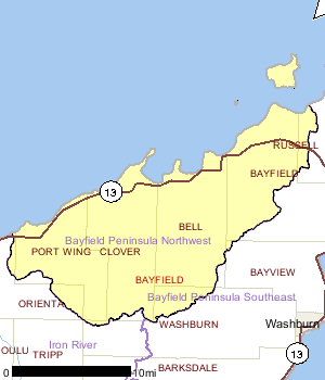
This watershed includes the western half of the Bayfield Peninsula and Sand Island of the Apostle Islands. Sand Island is managed by the National Park Service from its Bayfield office. The U.S. Forest Service manages portions of the watershed as part of the Chequamegon National Forest.
A number of streams draining the Bayfield peninsula have coastal wetlands at their mouths. Two sites in this watershed, the Flag River and Cranberry River, are part of the South Shore of Lake Superior Fish and Wildlife Area, a WDNR land acquisition project. The project was approved in 1992 with an acquisition goal of 8,690 acres. The project goal is to maintain and enhance highly valuable coastal wetlands and watersheds supporting migratory trout and salmon species.
Saxine and Squaw creeks and an unnamed stream at T51N R5W S19 form small areas of coastal wetlands at their mouths in Squaw Bay. Other than these coastal wetlands, the Squaw Bay shoreline is primarily sand beach. The western arm of the bay forms Squaw Point, off of which lake trout spawn. The Lake Superior Binational Program identified these small tributaries to Squaw Bay as important to the integrity of the Lake Superior ecosystem for coastal wetlands and fish and wildlife spawning and nursery grounds.
The shoreline from the mouth of Saxine Creek in Squaw Bay east beyond the watershed boundary between Sand Bay and Little Sand Bay is under federal protection as part of the Apostle Islands National Lakeshore. This area includes some unique land features, including undercut cliffs that form sea caves. Little Sand Bay is a small inlet between Big Sand Bay and Point Detour. It sports a small area of coastal wetlands, a sand beach, and hemlock and cedar. The National Park Service owns this area; tour cruises operate from a small marina. This area is identified by the Lake Superior Binational Program as habitat important to the integrity of the Lake Superior ecosystem for coastal wetlands and rare communities.
The lower reaches of this watershed, like most in the basin, has unstable red clay soils that are easily eroded if the soil is disturbed. Forestry activities in red clay soils need to employ best-management practices that are even more protective of riparian areas.
Date 1999
Nonpoint and Point Sources
The community of Herbster discharges its treated wastewater from the Clover Sanitary District directly to Lake Superior. The Bell Sanitary District in Cornucopia discharges seasonally to Lake Superior via a dry run and drop from a bluff to the lake. The community of Port Wing discharges effluent to Bibon Lake, which is connected to Lake Superior via wetlands.
Date 1999

Ecological Landscapes
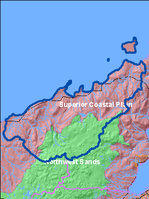
The Bayfield Peninsula Northwest Watershed is located within two ecological landscapes: the Northwest Sands and the Superior Coastal Plains.
The Northwest Sands Ecological Landscape is a large glacial outwash system consisting of two major landforms: flat plains or terraces along glacial meltwater channels, and pitted or "collapsed" outwash plains containing kettle lakes. Soils are deep sands, low in organic material and nutrients.
Historic vegetation at the time of the General Land Office survey was dominantly jack pine and scrub oak forest and barrens. White and red pine forests were also a sizable component of the Ecological Landscape. Numerous barrens occurred in the southwest half of the Ecological Landscape, and a few large barrens within the northeast half. Most of the trees in the barrens were jack pine, but oak savannas also occurred in the south central part of the Ecological Landscape. Current vegetation is a mix of forest, agriculture, and grassland with some wetlands in the river valleys. Pine, aspen-birch and oak equally (27% each) dominate the forested area of the Ecological Landscape. The maple-basswood, spruce-fir, and lowland hardwood forest type groups occupy small percentages of the Ecological Landscape. Within the open lands, there is a relatively large proportion of grassland and shrub land, a small but locally significant amount of emergent/wet meadow and open water, and very little row-crop agriculture.
The Superior Coastal Plain is Wisconsin's northernmost Ecological Landscape, bordered on the north by southwestern Lake Superior and on the south by the Northwest Sands, the Northwest Lowlands, and the North Central Forest. The climate is strongly influenced by Lake Superior, resulting in cooler summers, warmer winters, and greater precipitation compared to more inland locations. Exposed coastal areas are subject to significant disturbance from windstorms, waves, ice, currents, and periodic water level fluctuations. These disturbance regimes play a significant role in determining both the landform and vegetation characteristics of the shoreline ecosystems. The major landform in this Ecological Landscape is a nearly level plain of lacustrine clays that slopes gently northward toward Lake Superior. The clay plain is separated into two disjunct segments by the comparatively rugged Bayfield Peninsula. An archipelago of sandstone-cored islands, the Apostles, occurs in Lake Superior just north and east of the Bayfield Peninsula. Wave carved sandstone cliffs bracket stretches of the Peninsula and also occur along the margins of several of the islands. Sand spits are a striking feature of the Lake Superior shoreline, typically separating the waters of the lake from inland lagoons and wetlands. The spits support rare and highly threatened natural communities such as beaches, dunes, interdunal wetlands, and pine barrens, and these in turn are inhabited by specially adapted plants and animals. The mouths of many of the streams entering Lake Superior are submerged, creating freshwater estuaries. A ridge of volcanic igneous rock, primarily basalt, forms the southern boundary of portions of this Ecological Landscape.
Historically the Superior Coastal Plain was almost entirely forested. A distinctive mixture of white pine, white spruce, balsam fir, paper birch, balsam poplar, trembling aspen, and white cedar occurred on the lacustrine clays. White pine was strongly dominant in some areas, according to mid-nineteenth century notes left by surveyors of the US General Land Office. Mesic to dry-mesic forests of northern hardwoods or hemlock hardwoods were more prevalent on the glacial tills of the Bayfield Peninsula and throughout the Apostle Islands. Large peatlands occurred along the Lake Superior shoreline, often associated with drowned river mouths and well-developed sand spits. The most extensive of these wetland complexes were on the Bad and St. Louis rivers. A few large peatlands also occurred at inland sites, such as Bibon Swamp, in the upper White River drainage, and Sultz Swamp on the northern Bayfield Peninsula. The present clay plain forest has been fragmented by agricultural use, and today approximately one-third of this landscape is non-forested. Most of the open land is in grass cover, having been cleared and then subsequently pastured or plowed. Aspen and birch forests occupy about 40% of the total land area, having increased in prominence over the boreal conifers. On the Bayfield Peninsula, second-growth northern hardwood forests are interspersed among extensive early successional aspen stands. Older forest successional stages are now rare throughout the Superior Clay Plain.
Date 2010
Wildlife and Habitat
BIRDS
American Bittern - Botaurus lentiginosus
Bark Bay Slough, Port Wing Boreal Forest/Bibon Lake Marsh
American Peregrine Falcon - Falco peregrinus anatum
Squaw Bay Eyrie Cliffs
Bald Eagl - Haliaeetus leucocephalus
Various, Bibon Lake Marsh, Bark Bay
Blackburnian Warbler - Dendroica fusca
Sand Island
Blue-Winged Teal - Anas discors
Bibon Lake, Bark Bay
Common Loon - Gavia immer
Bark Bay
Common Tern - Sterna hirundo
Lost Creek
Connecticut Warbler - Oporornis agilis
Sand Bay
Evening Grosbeak - Coccothraustes vespertinus
Lost Creek Bog
Golden-Winged Warbler - Vermivora chrysoptera
Siskiwit Swamp, Sultz Swamp, Bark Bay, Lost Creek
Gray Jay - Perisoreus canadensis
Sand Bay
Merlin - Falco columbarius
Lost Creek Bog, Bark Bay
Nashville Warbler - Vermivora ruficapilla
Bibon Lake Marsh, Siskiwit Swamp, Sultz Swamp, Bark Bay, Lost Creek
Northern Harrier - Circus cyaneus
Lost Creek, Bark Bay
Redhead - Aythya americana
Bark Bay
Swainson's Thrush - Catharus ustulatus
Sand Island
Ruby-Crowned Kinglet - Regulus calendula
Siskiwit Swamp, Sultz Swamp, Lost Creek
Tennessee Warbler - Vermivora peregrina
Sand Bay
Veery - Catharus fuscescens
Bibon Lake Marsh, Siskiwit Swamp, Bark Bay, Lost Creek
Wilson's Warbler - Wilsonia pusilla
Bark Bay
Yellow-Bellied Flycatcher - Empidonax flaviventris
Port Wing Boreal Forest, Lost Creek Bog, Siskiwit Swamp, Sultz Swamp, Sand Bay
Yellow Rail - Coturnicops novaboracensis
Bark Bay
BUTTERFLIES AND MOTHS
Bog Copper - Lycaena epixanthe
Port Wing Boreal Forest, Lost Creek Bog, Bark Bay, Sand Bay
Bog Fritillary - Boloria eunomia
Lost Creek Bog, Bark Bay Slough, Sand Bay
Coral Hairstreak - Satyrium titus
Lost Creek Roadside
Dorcas Copper - Lycaena dorcas
Sultz Swamp
Great Copper - Lycaena xanthoides
Squaw Point Field
Hoary Elfin - Incisalia polia
Lost Creek Bog
Inornate Ringlet - Coenonympha tullia
Squaw Point Field, Bark Bay Slough
Reakirt's Blue - Hemiargus isola
Tawny Crescent Spot - Phyciodes batesii
Squaw Point Field, Bark Bay Slough
DRAGONFLIES
Black Meadowhawk - Sympetrum danae
Port Wing Boreal Forest
Lake Darner - Aeshna eremita
Port Wing Boreal Forest
RARE MACOINVERTEBRATES
Coleoptera; Family Dytiscidae - Sanfilippodytes pseudovilis
Sand River, Saxine Creek
Coleoptera; Family Dytiscidae - Oreodytes scitulus
Sand River
Odonata; Family Cordulegastridae - Cordulegaster obliqua
Flag River, Lost Creek No. 3, Racket Creek, Sand River
Trichoptera; Family Limnephilidae - Onocosmoecus unicolor
Bark River, East Fork Cranberry River, Flag River, East Fork Flag River, Racket Creek, Sand River, Saxine Creek
Trichoptera; Family Limnephilidae - Psychoglypha subborealis
Bark River, East Fork Cranberry River,Flag River, East Fork Flag River, Lost Creek No. 1, Saxine Creek
Trichoptera; Family Rhyacophilidae - Rhyacophila brunnea
East Fork Cranberry River, East Fork Flag River, Saxine Creek
Date 1999
Aquatic Invasive Species
Sultz Swamp
This acid peatland occupies a depression high on the Bayfield Peninsula about six miles inland from the Lake Superior coast. Although there are other, similar wetlands in this part of the basin, Sultz Swamp is the largest and embedded within vast stretches of county-owned forest. The major features of this insular peatland include mature forest of black spruce, and extensive muskeg/open bog and large populations of several rare species. Disturbances to the interior of the site have been minimal, with the exception of a maintained power line corridor that crosses the area east-west. White cedar logs were removed from the margins of the wetland in the distant past.
Underneath its closed canopy, the spruce forest is very open and park-like. Canopy gaps are filled with thickets of young black spruce or tamarack.
Where peat has accumulated and forms a deep, hummocky layer of sphagnum, the spruce and tamarack become scattered and often stunted. The understory is dominated by heath-like shrubs. Dense patches of blueberries possibly provide evidence of past fire, as does gnarly jack pine among the stunted spruces. Of special interest is a large population of Michaux's sedge, a Wisconsin Threatened plant.
Among resident birds are the solitary vireo, yellow-bellied flycatcher, ruby-crowned kinglet, Lincoln's sparrow and palm warbler. Large numbers of white-winged crossbills were noted in 1996, but breeding couldn't be confirmed.
Sultz Swamp is county-owned and designated as a wild are in the Bayfield County 10-Year Forest Management Plan, with the intent that it be allowed to return to a natural state, with as little management as possible (Fenner). This plan says motor vehicle travel will be limited to maintenance and winter snowmobiles only (Fenner). Managers should work with the utility responsible for maintaining the power line corridor to ensure that introduction of invasive species is avoided and that no harmful chemicals are used in keeping the corridor open.
Date 1999
Rivers and Streams
All Waters in WatershedWatershed Trout StreamsWatershed Outstanding & Exceptional ResourcesLakes and Impoundments
Impaired Waters
List of Impaired Waters Watershed History Note
The community of Cornucopia, along Siskiwit Bay in Lake Superior, is located in the Bayfield Peninsula Northwest watershed. The Ojibwe Indians used the bay area as a temporary camp and a stopover on the way to La Pointe on Madeline Island. The name Siskiwit comes from an Ojibwe word for a subspecies of lake trout known in English as "fat trout".
The first white settlers in the Siskiwit Bay area were loggers who came at the close of the nineteenth century. Remnants of this period include abandoned railroad pilings in Siskiwit Lake. The first farmers who came to the Town of Bell came via Chicago and represented ethnic groups found in the mountainous borderlands of Poland, Slovakia, Ukraine, and Romania.
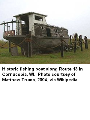
Commercial fishing for lake trout, whitefish and freshwater herring has traditionally operated out of Cornucopia's harbor. In 1903, land speculators from Iowa established a post office and gave the village the name "Cornucopia" for its abundance of resources.
After World War II, Cornucopia's natural beauty led tourism to replace logging, farming, and fishing as the dominant industry of the community. Today, most working-age residents are engaged in trades, service, or seasonal employment.
Date 2010